Showing posts with label streets. Show all posts

Sunday, February 7, 2016

A Brooklyn-Queens Street Car

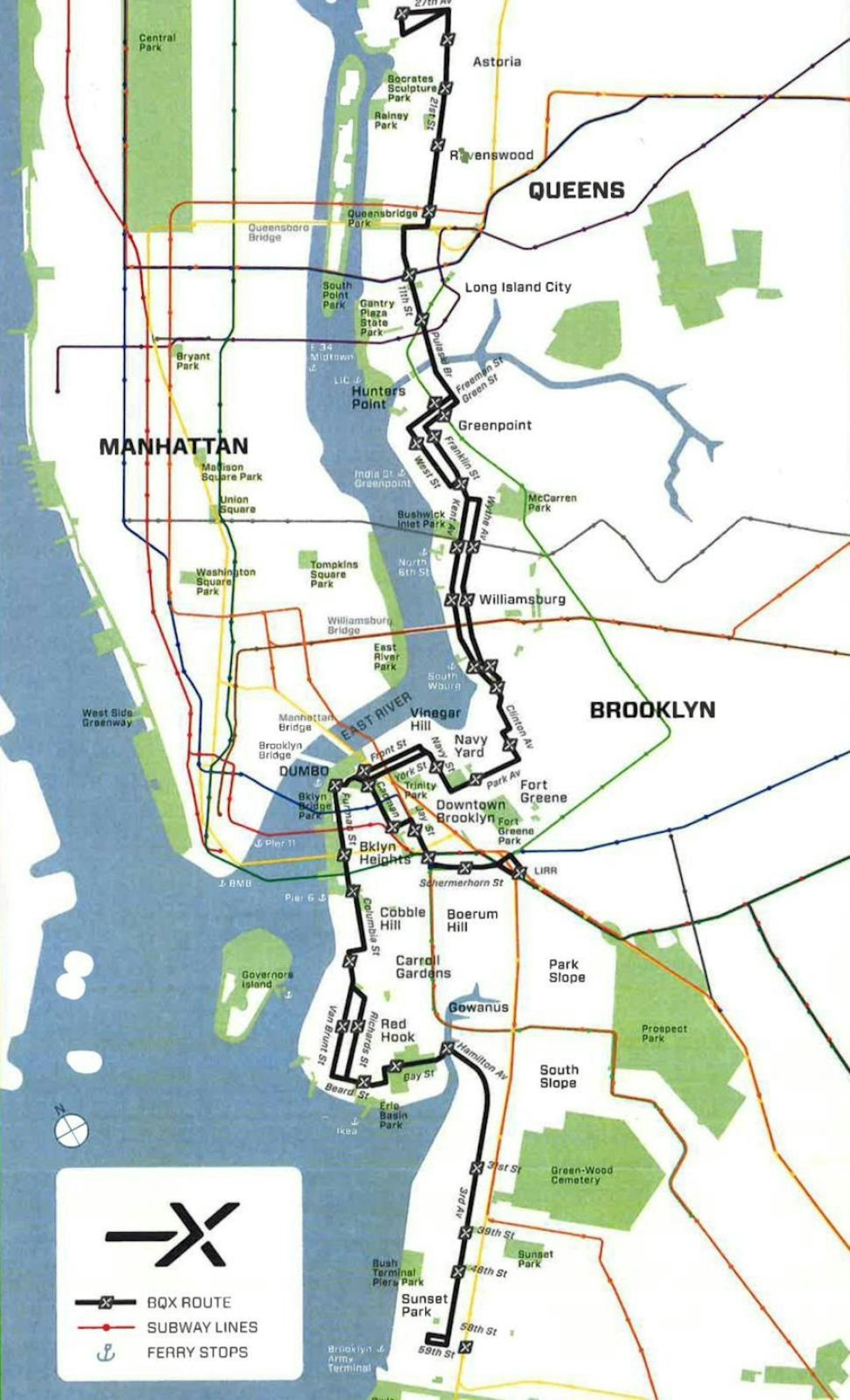
At Thursday night's State of the City address, Mayor Bill De Blasio announced a proposal to add a new street-level tram along the Brooklyn and Queens waterfront. The BQX street car would run from Sunset Park up to Astoria, passing through several waterfront neighborhoods that do not have subway access, like Red Hook. Preliminary maps show the trolley traveling along Columbia Street, with a station at Pier 6. In addition to the expanded East River Ferry service, this is the second new transit route proposed for the Columbia waterfront.

The plan's $2.5 billion price tag has been criticized by some transit advocates, who suggest that the money could be put to better use increasing express bus service or expanding transit options in more poorly served areas. Questions about the future line's ridership and its integration with the MTA Metrocard are still unanswered. The project will begin gathering community input this year, and is expected to get construction permits no earlier than 2017.

Brooklyn train enthusiast Bob Diamond, who discovered the Cobble Hill Tunnel under Court and Atlantic in 1981, has long been an advocate for the return of the waterfront trolley that ran through Red Hook and DUMBO. He lauded Thursday's news, and hopes to work with the De Blasio administration to make the new proposal a reality.

Additional coverage:

Tuesday, April 17, 2012

Making Safer Neighborhoods

In February, NYC's premier advocacy group for walking, biking, and mass transit Transportation Alternatives, met with parents from the Cobble Hill/Columbia Waterfront/Carroll Gardens/Red Hook area to begin a study on street safety. This Wednesday night is a follow up meeting at the Carrol Gardens to have a community conversation on the project's scope as it seeks families with children ages 6 to 11 who can walk and who have a parent/guardian also able to walk.
Wednesday, April 18, 6-8 pm
Carroll Gardens Library - 396 Clinton Street at Union Street

light dinner will be served  

Those who do choose to participate will be asked to take pictures of streets and public spaces in their neighborhood and adults will also complete a short survey. Each family will receive a $25 gift card in thanks for their time, but more importantly will help advance all neighborhood's shared goals of safer streets.
 
Additional details are available on the flier above, and follow up questions, as well as an RSVP (requested, but not required) can be sent to Stephanie Kneeshaw-Price.
Phone: 646 873-6039
Email: stephanie@transalt.org

Walkable Cobble Hill

This article already made the rounds last week but it's worth sharing here now too far all who missed it.  We all know NYC is a pretty walkable place and even with an inadequately funded mass transit system and a still growing bicycle infrastructure, its density still allows many people to regularly rely on two feet rather than two wheels. WalkScore is a system that rates and promotes that ability because
  • People in walkable neighborhoods weigh 6-10 lbs less.
  • Walkable places make you happier and healthier.
  • Short commutes reduce stress and increase community involvement.
Cobble Hill and the adjacent neighborhood of Brooklyn Heights, both reached the city's highest scores - 98 out of 100. Congrats Cobble Hill!

To read more check out the L Magazine's write up... and visit Walk Score's website & breakdown.
http://www.thelmagazine.com/TheMeasure/archives/2012/04/13/the-most-and-least-walkable-neighborhoods-in-brooklyn

Thursday, February 23, 2012

Street Study seeks Parents & Kids

Transportation Alternatives is NYC's leading advocacy group for pedestrians, cyclists, and mass transit users and they are now beginning a street study comparing Brooklyn neighborhoods... one of which will be in our own area. To gather detailed information on how we use our streets, T.A. is seeking parents for a 15-25 minute survey about themselves, their physical activity, and their neighborhood. Participating families will receive a small gift in appreciation of their time and input. Full details are available by clicking on the  adjacent flyer or contacting Stephanie Kneeshaw-Price, stephanie@transalt.org.

Wednesday, May 12, 2010

Small signs, Big Changes

Cobble Hill is privilege to some minor tweaks that could have big impacts on quality of life citywide. First, have you noticed the orange decals popping up on our streets? There's one on Henry Street and one on a Congress street manhole cover spotted recently. They're part of a pilot program that makes it much easier to know a problem has already been reported to 311 and is being remedied.

'When a customer calls 311 to report a condition for repair, a City inspector will visit the site and determine the necessary next steps.  For many issues, private companies, utilities or other City agencies may be required to respond which may influence the duration of repair.  City inspectors will affix a small, bright orange decal adjacent to the site.  For issues that are repaired immediately, no decal will be used.'

If it works well in our neighborhood, perhaps it will speed up the 311 system and simplify confusion.
More info is available on this downloadable flyer.

Another change to our streets is already proving successful at taming traffic: Neckdowns.

Also known as bulb outs, or sidewalk extensions, these subtle changes to the streetscape create a visual road narrowing that makes drivers slow down while making turns or passing through intersections (which is where the overwhelming majority of accidents happen).  Now some drivers may not enjoy a pinch point in the road preventing their speeding, but NYC is walking city where the majority does not own a car, yet traffic "accidents" are sky high. And those who do drive, are also pedestrians after they park, so they too will benefit from the shorter crosswalk and slower vehicle traffic.

While our neighbors in Boerum Hill received an enormous neckdown last year, which will soon house an art instalation and slew of bike racks, many corners in Cobble Hill have had similar facelifts. Over the past few months the safety enchancement was given to northwest corner of Hicks & Union, the southeast corner of Henry and Atlantic, and most recently both southern corners of Clinton and Atlantic. Hundres of pedestrians and cyclists cross that intersection every morning and now they will all move a little safer. Thank you Department of Transportation's new Street Design Manual!


Friday, November 21, 2008

Fewer trucks on Henry Street thanks to smart thinking

We are very proud of the ingenuity of the CHA Green Committee for their success in getting commerical map maker Hagstrom to recolor Henry Street on its maps and atlases, used by truckers all across the country. Because of their work, starting next spring, fewer trucks will wind up on Henry Street. Our streets will be safer and our lungs healthier. Here is CHA Green Czar Dave 'Paco' Abraham's report:
Reducing Truck Traffic, One Map at a Time

Cobble Hill is a residential neighborhood whose adjacency to the congested Brooklyn Queens Expressway often brings about non-local truck traffic, in particular along Henry Street. Some truck drivers intentionally cut through Cobble Hill and Carroll Gardens to avoid highway traffic, while others are simply lost, misdirected, and relying on a poorly designed map. Recognizing the latter as a danger to Henry Street's bike route, as well as a burden on neighborhood air quality, the Cobble Hill Green Committee aimed to cut the error off at its source.

Committee member Laura Herzenhorn, herself often behind an oversize vehicle for the American Museum of Natural History, pointed out that many truck drivers rely on the well-known Hagstrom Map books which identify Henry Street with a solid yellow line, properly indicating it as a through-street for regularly sized vehicles. While the Hagstrom Map does not condone trucks using car through-streets, it does falsely assume Henry Street's width. Unlike the Carroll Gardens segment of Henry Street, the Cobble Hill corridor has an extremely narrow width, which poses an extreme danger for trucks assuming they can pass safely. Committee chairperson Dave 'Paco' Abraham spoke with Hagstrom's research department and they have agreed to remove the yellow fill on Henry Street during the next map printing, expected in March of 2009.

Additionally, Hagstrom Maps is now working to publish a NYC map specifically for truck drivers to reduce the frequency of non-local traffic falsely assuming the roads highlighted yellow are wide enough for their oversize loads. A stronger police watch of traffic laws is the only surefire way to curb illegal truck driving, but fixing the Hagstrom Map error is at least one small interim step until major enforcement policy is overhauled.